
An Edible Orchard in Los Angeles

Volunteers plant fruit trees at Del Aire Fruit Park in Hawthorne, CA. Photo via Fallen Fruit.
On Saturday, January 5th, a revamped Del Aire Park in Los Angeles’ South Bay was revealed to its neighbors. The new park received $4 million dollars in upgrades to its community center, basketball court, and baseball field and in addition to these upgrades, a grant was secured through the Los Angeles County Arts Commission Civic Art Program to plant 27 fruit trees at the park and an additional 60 fruit trees around the neighborhood.
The fruit park (the first of its kind in the state) was created in collaboration with The Office of Supervisor Mark Ridley-Thomas and the Los Angeles County Department of Parks and Recreation and planted by artist collective Fallen Fruit, a group that invites “the citizens of Los Angeles to reconsider their relationship with public and urban space to explore the meaning of community through sharing and creating new and abundant resources.”

Volunteers plant fruit trees at Del Aire Fruit Park in Hawthorne, CA. Photo via Fallen Fruit.

At the opening of the park, Supervisor Mark Ridley-Thomas said that “Community gardens and farmers markets are truly the town centers of our communities,” and they become spaces where the community gets to know one another. These kinds of resources can also be incredible important in neighborhoods that do not have easy access to healthy foods.
Over time, the fruit trees in the park and around the neighborhood will grow and give the community plums, pomegranates, peaches, limes, avocados, and apricots, as well as grapes and edible herbs. A wooden sign by the orchard reads: “The fruit trees in this park belong to the public. They’re for everyone, including you. Please take care of the fruit trees and when the fruit is ripe, taste it and share it with others.”
San Francisco’s Public Parklets

Parklet in front of Farm : Table cafe on Post Street in San Francisco. Photo by Anna Peccianti

“Parklets” are small pocket parks built inside of former street-side parking spaces. The idea behind parklets is that you can take a small amount of space (like one, two, or three parking spaces) and turn it in to something that can be a public amenity.
Parklets are intended to be open to the public and are usually situated in front of a restaurant or market. The design of parklets can vary widely and unfortunately, certain design elements can sometimes give the impression that the parklet is private seating specific to that restaurant or market instead of a space open to the general public. For example, crowded parklets full of bistro tables and high, dense walls can look like cafe seating while parklets with varying seating and standing options (the red parklet below has a tall bar where you can place your elbows or food and beverages) and an open design with high visibility can appear to be more welcoming and meant for anyone to relax in and enjoy.
San Francisco has been a leader in the parklets movement and their Pavement to Parks program works with businesses to build parklets in front of their shops/restaurants. When I was home for the holidays, I visited San Francisco and snapped a few photos of some parklets that seemed to be working well as approachable and accessible public spaces- even on a cold and rainy day.
Parklet in front of Farm : Table on Post Street in San Francisco. Photo by Anna Peccianti


Parklet in front of Martin Macks on Haight Street in San Francisco. Photo by Anna Peccianti


Parklet in front of Haight Street Market on Haight Street in San Francisco. Photo by Anna Peccianti

Hurricane Sandy Brings Environmental Concerns to Light
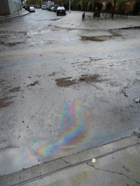
Oil sheen in Brooklyn after Hurricane Sandy. Photo by Newtown Creek Alliance.

After Hurricane Sandy, the Environmental Protection Agency (EPA) posted information on its website about taking safety precautions when cleaning up after floods but many community advocates in New York and New Jersey are increasingly concerned about the levels of contamination caused by Sandy and their impact on clean up efforts as well as the environmental threat of future storm surges and rising seal levels near current and former industrial waterfront areas.
In Brooklyn, New York, two Superfund (hazardous waste) sites, the Newtown Creek and Gowanus Canal breached their banks and flowed in to nearby city streets. In New Jersey, the Raritan Bay Slag Superfund Site (containing large amounts of lead, arsenic and copper) flooded an adjacent public playground and beach and in the Arthur Kill (a channel between New Jersey and Staten Island), clean up crews working in cooperation with the Coast Guard had to use oil skimmers, vacuum trucks and a contamination boom to remove 378,000 gallons of fuel released from the Motiva oil tank during the storm.
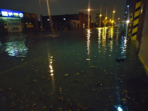
Greenpoint Avenue (near a sewage treatment plant) in Greenpoint, Brooklyn after Hurricane Sandy. Photo by Newtown Creek Alliance
%20in%20Greenpoint%2C%20Brooklyn%20after%20Hurricane%20Sandy.%20Photo%20by%20Newtown%20Creek%20Alliance%20%2F%2F%20The%20Accessible%20City "Pin It")
Environmental justice (advocating for communities unfairly burdened by environmental pollution and contamination) advocates are requesting to meet with local city officials and waterfront businesses to inventory existing chemicals and help keep businesses up to date on floodproofing their chemical storage facilities. Kate Zidar, Executive Director of the Newtown Creek Alliance says “Learning from Sandy, we need environmental health and safety information for flooding that is specific for Superfund and relevant to the industrial business community,” and suggests potential efforts that could help prevent further contamination in the future like installing tide gates and shoreline bulkheads and the restoration of our wetland areas.
Communities who live near businesses like chemical plants, paper mills, and ports or infrastructure like highways are unfairly burdened by negative health outcomes and advocating for regulation of these facilities, progressive environmental planning and affordable housing in healthier communities are key to saving millions of our fellow citizens from undue suffering.
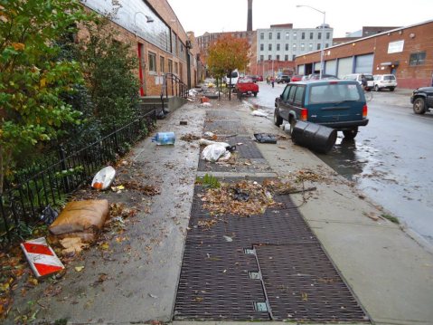
Ash Street in Greenpoint, Brooklyn after Hurricane Sandy. Photo by Newtown Creek Alliance

An Abandoned Walmart Transformed
McAllen Public Library. Photo via The New York Times.

According to the New York Times, more than 130 former Walmart stores are vacant and available for purchase or lease across the country. With many big box stores and malls closing, we have the opportunity to think of ways to reuse these structures instead of letting them sit abandoned, open to negative activity.
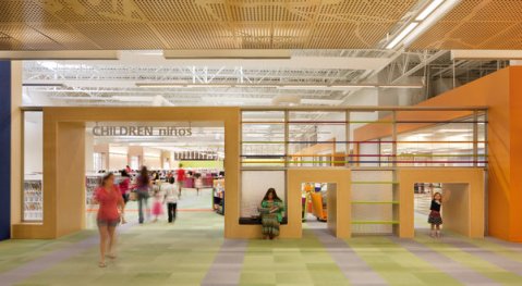
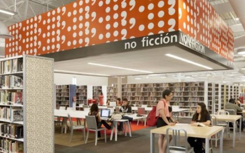
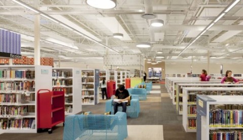
In McAllen, Texas, the city transformed a former Walmart (the size of two and a half football fields) into a contemporary library filled the space with innovative amenities like an art gallery, cafe, used book store, an auditorium, meeting rooms with audiovisual services and electronic classrooms.
The new library is an upgrade from the city’s former library and has drawn a large number of people (about 62,000 people came to the library in July, up from 28,000 visitors this time last year) but some have criticized the library for being outside of the city center and I could not tell from the website if it was accessible by public transportation.
How would you transform a former big box store? What would you do with all that space?!? I’d love to do a workshop with children and hear what kind of imaginative ideas they’d have for a building that size. Water slides? Roller coasters? Skateboarding park? Petting zoo? The possibilities are endless.
McAllen Public Library. Photo via PSFK.

McAllen Public Library. Photo via PSFK.
Sunset Triangle Plaza
Cities like New York and San Francisco have lead the way in the transformation of our largest public space, our city streets. They have successfully created comfortable, vibrant and welcoming public plazas constructed efficiently and inexpensively by using paint and temporary materials. These plazas can help calm traffic (decreasing incidents of pedestrian and cyclist injury and fatality), encourage walking and cycling (contributing to personal and public health through exercise and the decrease of carbon emissions from cars), and can benefit local businesses (because when you create an attractive space, people are more likely to linger and patronize nearby shops and restaurants.
The hallmarks of these public spaces are their location (converting redundant or wide streets in areas that already have high levels of commercial, pedestrian or cyclist activity), their customizable nature (moveable seating and chairs are always preferable because you can feel comfortable to sit alone or in large groups), and their accessibility (no stairs, adjacent to crosswalks and sidewalks, lots of seating options, shade and visibility).

Madison Square Plaza, NYC. Photo by Anna Peccianti
%20%2F%2F%20The%20Accessible%20City "Pin It")
Los Angeles, with it’s warm weather, wide boulevards and high levels of pedestrian activity in certain neighborhoods could be a perfect playground for these types of public spaces. Last year the Los Angeles Department of Public Health received a grant to decrease obesity rates in Los Angeles and together with the Department of City Planning, they decided to put that money towards Los Angeles’ first street-to-plaza conversion project.

Sunset Triangle Plaza. Photo by Anna Peccianti
%20%2F%2F%20The%20Accessible%20City "Pin It")
This particular location was chosen because a) the community had been asking for a pedestrian plaza in this area for over 10 years, b) there was already a twice-weekly farmer’s market in this location so the street already had consistent pedestrian activity; and c) as previously mentioned, the street is redundant and sandwiched between a small triangular park and popular businesses whose patrons were usually crowding the tiny sidewalks with bicycles and belongings.

Sunset Triangle Plaza Draft Plan by Rios Clementi Hale Studios
Sunset Triangle Plaza is a one-year pilot project. Early next year community members, city agencies and elected officials will determine whether or not the plaza will become something more permanent or be converted back in to a street.
Street-to-plaza conversion projects can be hard to visualize if you’ve never seen or experienced one before. The wonderful thing about creating temporary demonstration projects is that they allow a city to inexpensively transform public space so residents can see for themselves just how transformative these types of spaces can be.
Sunset Triangle Plaza from Streets for People on Vimeo.
